Government Grants
Business Grants
Home Owner Programs
Federal Programs
About Us
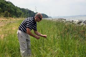
BLM OR-WA Vegetation Mapping Utilizing Remote Sensing, Burns
There is a need for quantitative multiple-scale vegetation mapping and data that is reliable, scale-appropriate, versatile, and easy to use.
The Burns District believes that remote sensing technology has evolved over the past 15 years such that these technologies can augment existing vegetation
datasets in a very meaningful way.
A remotely sensed dataset would provide land managers cost effective data in order to learn from past actions and improve on future management.
Burns District BLM would like to cooperate with entities involved in the development of these types of technologies to build and adapt a data rich information feedback system for public and private managers in Harney County, that accurately measures landscape conditions and serves as a platform to make sound management decisions.
The Burns BLM and adjacent land managers (public and private) face many complex resource related issues, including:
conservation of Greater Sage-grouse, invasive plant species, juniper encroachment, prevention and responses to wildfire, wildlife habitat, rangeland health, permit renewal, carrying capacity, and riparian conditions and trends.
The overall objective of this project is to assist with the development and implementation of new technologies that more efficiently, effectively, and economically monitor and inventory vegetation resources in order to assist with, and evaluate, management actions at multiple-scales.
Activities may include, but not be limited to:
â¿¢Development of remote sensing technologies; â¿¢Assessing landscape-wide vegetative and functional cover characteristics; â¿¢Creating vegetation maps; â¿¢Analyzing data to best meet land management needs; â¿¢Assisting with data integration collected from multiple resources; â¿¢Sharing the analyzed data with land managers to assist with management decisions at multiple scales; â¿¢Retain and maintain the data in a format that can be accessed and used by multiple land managers; and â¿¢Monitoring changes to vegetation that result from management actions.
Who's Eligible
Relevant Nonprofit Program Categories
Obtain Full Opportunity Text:
http://www.grants.gov/
Additional Information of Eligibility:
There is not an application process for this funding opportunity.
This is a notice of intent to award a single source grant to the Toledo Zoological Society under justification 505DM 2.14.B.1 and 4.
Full Opportunity Web Address:
http://www.grants.gov/
Contact:
Justin Chiotti 248-891-0087justin_chiotti@fws.gov
Agency Email Description:
Fish Biologist
Agency Email:
justin_chiotti@fws.gov
Date Posted:
2016-06-28
Application Due Date:
2016-08-29
Archive Date:
2017-06-28
Social Entrepreneurship
Spotlight
Building a Million Dollar Company Where Everyone Counts

Ganesh Natarajan is the Founder and Chairman of 5FWorld, a new platform for funding and developing start-ups, social enterprises and the skills eco-system in India. In the past two decades, he has built two of India’s high-growth software services companies – Aptech and Zensar – almost from scratch to global success.
Learn How to Identify and Avoid Grant Scams
