Government Grants
Business Grants
Home Owner Programs
Federal Programs
About Us

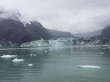

Inspire Cooperative Coastal Change Adaptation Through Locally-S
This is NOT a request for applications.
This is just an announcement that NPS is continuing its current cooperative agreement with the Trustees of Boston University.
The major product of this project will be a full coastal vulnerability report, assessing eachisland cluster, for each of three SLR scenarios, and associated model output data products, maps,and interpretive graphical products.
We will also provide an interim summary of our progressannually and pass across data each year as the project progresses so that it can be used by NPSand stakeholders as soon as possible.
The project analyses and report will assess the relativevulnerability of each distinct coastal area of each island according to substrate resilience,topography, and exposure to storms, Boston Harbor sediment dynamics, and possible thresholdcrossings.
The resulting analyses will include locally-scaled predictions that can then be testedby simple monitoring such as:
the vulnerability of seawalls to overtopping; the predictedfrequency of storm overwashing in primary dune and gravel overwash ridge areas; areas wherehigh volume overwash deposition events are possible; approximate bluff and shoreline retreatrates for the modeled sea-level elevations; and most critically, areas where infrastructure andcultural and natural resource vulnerability to storm impacts is highest.
Simple indicators that canbe easily monitored will be identified (e.g.
for absolute sea level, and/or frequency of inundationof index sites), and thresholds to trigger management decision–making will be established.Specific scientific deliverables from the cooperator will include simple but powerful metricsincluding:
1. Beach and bluff retreat rates for selected areas of each of the three islands; 2. Authoritative, high accuracy map layers for:a.
Coastal substrate type (e.g.
seawall, riprap, rocky bluff, glacial till bluff, cobblebeach, salt marsh etc.), and the relative resilience to dismantling/erosion of each;b.
The location and elevation of all significant cultural and natural resources andvisitor facilities;c.
Measured and predicted erosion and deposition areas in Boston Harbor and theislands, including hot spots of scarp retreat; andd.
Predicted areas of high volume overwash deposition events.The report will include, details of:
1. Areas where infrastructure and cultural and natural resource vulnerability to stormimpacts is highest; 2. The capacity for management success in protecting resources in high vulnerabilityareas; 3. The predicted frequency of storm overwashing; and 4. Recommended monitoring sites and methods that could be used to provide earlywarning of likely threshold crossings.
This is just an announcement that NPS is continuing its current cooperative agreement with the Trustees of Boston University.
The major product of this project will be a full coastal vulnerability report, assessing eachisland cluster, for each of three SLR scenarios, and associated model output data products, maps,and interpretive graphical products.

We will also provide an interim summary of our progressannually and pass across data each year as the project progresses so that it can be used by NPSand stakeholders as soon as possible.
The project analyses and report will assess the relativevulnerability of each distinct coastal area of each island according to substrate resilience,topography, and exposure to storms, Boston Harbor sediment dynamics, and possible thresholdcrossings.
The resulting analyses will include locally-scaled predictions that can then be testedby simple monitoring such as:
the vulnerability of seawalls to overtopping; the predictedfrequency of storm overwashing in primary dune and gravel overwash ridge areas; areas wherehigh volume overwash deposition events are possible; approximate bluff and shoreline retreatrates for the modeled sea-level elevations; and most critically, areas where infrastructure andcultural and natural resource vulnerability to storm impacts is highest.
Simple indicators that canbe easily monitored will be identified (e.g.
for absolute sea level, and/or frequency of inundationof index sites), and thresholds to trigger management decision–making will be established.Specific scientific deliverables from the cooperator will include simple but powerful metricsincluding:
1. Beach and bluff retreat rates for selected areas of each of the three islands; 2. Authoritative, high accuracy map layers for:a.
Coastal substrate type (e.g.
seawall, riprap, rocky bluff, glacial till bluff, cobblebeach, salt marsh etc.), and the relative resilience to dismantling/erosion of each;b.
The location and elevation of all significant cultural and natural resources andvisitor facilities;c.
Measured and predicted erosion and deposition areas in Boston Harbor and theislands, including hot spots of scarp retreat; andd.
Predicted areas of high volume overwash deposition events.The report will include, details of:
1. Areas where infrastructure and cultural and natural resource vulnerability to stormimpacts is highest; 2. The capacity for management success in protecting resources in high vulnerabilityareas; 3. The predicted frequency of storm overwashing; and 4. Recommended monitoring sites and methods that could be used to provide earlywarning of likely threshold crossings.
Relevant Nonprofit Program Categories
Obtain Full Opportunity Text:
http://grants.nih.gov/grants/guide/rfa-files/RFA-NR-09-005.html
Additional Information of Eligibility:
This is NOT a request for applications.
This is just an announcement that NPS is continuing its current cooperative agreement with the Trustees of Boston University.
Full Opportunity Web Address:
http://grants.nih.gov/grants/guide/rfa-files/RFA-NR-09-005.html
Contact:
Agency Email Description:
BOHA BU
Agency Email:
Date Posted:
2018-08-14
Application Due Date:
Archive Date:
2018-08-24
Social Entrepreneurship
Spotlight
When it Comes to Social Enterprises, Failure is the Best Platform for Innovation

In the world of social enterprises, failure is a cringe-worthy moment nobody wants to talk about. But, social entrepreneurs can benefit from their failures.
Learn How to Identify and Avoid Grant Scams
