Government Grants
Business Grants
Home Owner Programs
Federal Programs
About Us
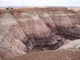
Wupatki Pueblo Geological Hazard Assessment
Partnering with the Museum of Northern Arizona on this project addresses the Secretary of the Interiorâ¿¿s Top Ten Priorities when considering Financial Assistance agreements.
Specifically, this project addresses the following:
1. a.
Utilize science to identify best
practices to manage land and water resources and adapt to changes in the environment.
Project Goal:
The goal of this project is to identify and evaluate potential geological hazards to the structural integrity of Wupatki Pueblo, a 100-room archaeological site constructed during the period AD 1125 â¿¿ 125 0. Much of the site is situated atop a narrow bedrock ridge and amongst a series of rockfall boulders.
The narrow ridge and boulders are inherently unstable, with downslope movement of the ruinâ¿¿s walls, and shifting of the boulders dominantly responding to the pull of gravity.
Consequently, walls exhibit shifting and cracking.
Additionally, rainfall runoff undermines many of the walls and a potentially outdated drainage system is in need of repair and reconfiguring.
This report will help park managers focus on stabilizing those walls and rooms of the 100-room structure that are the most likely to experience severe erosion and associated damage in the future.
Ancillary Benefit:
The major ancillary benefit of this project is providing monument visitors with interpretation material (3-dimensional model of Wupatki Pueblo in particular) and an opportunity for the public to learn about field sciences related to archeology and NPS preservation methods.
The 3-dimensional model will be put on display in the visitor center and on the parkâ¿¿s website as part of virtual reality tour.
B.
Project Objectives.
The objectives of this project are to use the sciences of hydrology (water movement), geomorphology (formation of physical geological features) and seismology (earthquakes) to identify locations at Wupatki Pueblo where severe erosion and architectural preservation issues are most likely to occur.
This project will start with documenting all architectural features within 50 meters of the pueblo with photographs and maps.
The next step is to create a three-dimensional (3D) model of Wupatki Pueblo and the surrounding landscape (1/4 mile surrounding the pueblo).
This will be accomplished with aerial imagery and laser scanning.
The 3D model will serve as the basis for the next step.
The next step is to complete in-field geomorphic mapping of landforms, bedrock geology, landslides, rockfalls, jointing patterns, faulting, areas of rilling, gullying, sheetwash and eolian erosion.
The mapping will be done using a geographical information systems program on an iPad to produce an erosion risk assessment map showing areas of erosion verses deposition relative to archeological features.
The primary focus of this phase is to characterize the underlying bedrock that supports the pueblo structure.
Settling and movement of the underlying landform is critical to understand because it could have devastating impacts like wall collapse.
Using the 3D model and aerial images of each room in the pueblo, the next step is to map the micro-drainage patterns on the floors and map the flow of water through the pueblo along an existing drainage system as well as water flow not being caught by the installed drainage system.
This will allow for the re-engineering of the existing drainage system to minimize erosion of the rooms.
The next step is a written report with maps showing the location of low, moderate and high vulnerability areas.
The 3D model and maps of the 100-room pueblo will be delivered to monumentâ¿¿s Division of Interpretation and Public Education staff for public programs.
Specifically, this project addresses the following:
1. a.
Utilize science to identify best

practices to manage land and water resources and adapt to changes in the environment.
Project Goal:
The goal of this project is to identify and evaluate potential geological hazards to the structural integrity of Wupatki Pueblo, a 100-room archaeological site constructed during the period AD 1125 â¿¿ 125 0. Much of the site is situated atop a narrow bedrock ridge and amongst a series of rockfall boulders.
The narrow ridge and boulders are inherently unstable, with downslope movement of the ruinâ¿¿s walls, and shifting of the boulders dominantly responding to the pull of gravity.
Consequently, walls exhibit shifting and cracking.
Additionally, rainfall runoff undermines many of the walls and a potentially outdated drainage system is in need of repair and reconfiguring.
This report will help park managers focus on stabilizing those walls and rooms of the 100-room structure that are the most likely to experience severe erosion and associated damage in the future.
Ancillary Benefit:
The major ancillary benefit of this project is providing monument visitors with interpretation material (3-dimensional model of Wupatki Pueblo in particular) and an opportunity for the public to learn about field sciences related to archeology and NPS preservation methods.
The 3-dimensional model will be put on display in the visitor center and on the parkâ¿¿s website as part of virtual reality tour.
B.
Project Objectives.
The objectives of this project are to use the sciences of hydrology (water movement), geomorphology (formation of physical geological features) and seismology (earthquakes) to identify locations at Wupatki Pueblo where severe erosion and architectural preservation issues are most likely to occur.
This project will start with documenting all architectural features within 50 meters of the pueblo with photographs and maps.
The next step is to create a three-dimensional (3D) model of Wupatki Pueblo and the surrounding landscape (1/4 mile surrounding the pueblo).
This will be accomplished with aerial imagery and laser scanning.
The 3D model will serve as the basis for the next step.
The next step is to complete in-field geomorphic mapping of landforms, bedrock geology, landslides, rockfalls, jointing patterns, faulting, areas of rilling, gullying, sheetwash and eolian erosion.
The mapping will be done using a geographical information systems program on an iPad to produce an erosion risk assessment map showing areas of erosion verses deposition relative to archeological features.
The primary focus of this phase is to characterize the underlying bedrock that supports the pueblo structure.
Settling and movement of the underlying landform is critical to understand because it could have devastating impacts like wall collapse.
Using the 3D model and aerial images of each room in the pueblo, the next step is to map the micro-drainage patterns on the floors and map the flow of water through the pueblo along an existing drainage system as well as water flow not being caught by the installed drainage system.
This will allow for the re-engineering of the existing drainage system to minimize erosion of the rooms.
The next step is a written report with maps showing the location of low, moderate and high vulnerability areas.
The 3D model and maps of the 100-room pueblo will be delivered to monumentâ¿¿s Division of Interpretation and Public Education staff for public programs.
Related Programs
Cooperative Research and Training Programs Resources of the National Park System
Department of the InteriorWho's Eligible
Obtain Full Opportunity Text:
http://www.grants.gov
Additional Information of Eligibility:
Foreign institutions are not eligible to apply.
Full Opportunity Web Address:
http://www.grants.gov
Contact:
Agency Email Description:
.
Agency Email:
Date Posted:
2018-06-12
Application Due Date:
Archive Date:
2018-06-28
Social Entrepreneurship
Spotlight
Building a Million Dollar Company Where Everyone Counts
Ganesh Natarajan is the Founder and Chairman of 5FWorld, a new platform for funding and developing start-ups, social enterprises and the skills eco-system in India. In the past two decades, he has built two of India’s high-growth software services companies – Aptech and Zensar – almost from scratch to global success.
Learn How to Identify and Avoid Grant Scams
